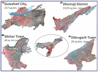
As a pilot study, Assam State Disaster Management Authority has engaged the North East Space Application centre for conducting the HRVA for Dhemaji district and Guwahati city, Dibrugarh & Silchar towns. HRVA proposes to focus on developing a data-base of disasters which will be collated, analyzed and validated to make appropriate risk information available. In addition to structural and physical vulnerabilities, social and economic vulnerability indicators shall be identified and assessed.These will help develop feasible multi-hazard risk and vulnerability assessments and the likely hazard-scenario.It will include an assessment of the probability and incidence of all major hazards. Further, the activity will also look atdifferential indicators of vulnerability including occupational and settlement patterns, poverty and migration, and socio-economic and cultural vulnerabilities etc. Theassessment reports will seek to prepare hazard maps, vulnerability and risk profiles and risk quantification and exposure data.
  The broad objective of HR & VA are The broad objective of HR & VA are
- To prepare GIS based multi hazard maps for Guwahati city, Silchar & Dibrugarh
towns (1:10,000 scale) and for Dhemaji district (1:25,000scale).
- To prepare vulnerability and risk assessment maps for probable multi hazards for the areas under study.
Overall methodology
In HRVA, there are three major phases: assessment of frequency-magnitude- damages related to past hazardous events for each study area; preparation of hazard zonation maps for probable hazards to assess physical & social vulnerability and risk for each of the hazards.
Hazard Zonation
Historical evidences showed that study areas are vulnerable to frequent flood incidences including flash floods, while Guwahati city is also prone to landslide activities especially during the monsoon period. There are some major industrial installations in and around the study areas, also making them vulnerable to industrial hazards. NE region falls into seismic zone V, hence, needs special emphasis to ascertain behaviour of the study areas for a given magnitude of earthquake in future to minimize related damage.
Flood Hazard Zonation
Flood is one of the most recurrent hydro-meteorological disasters. Urban flash flooding mainly due to inadequacy of drainage conveyance within urban areas is common for Guwahati City, Silchar and Dibrugarh towns. To address
this, base flood elevations are established using a coupled hydrologic-hydraulic simulation platform on high resolution topographic base layer aided by detailed ground survey through Electronic Total Station.
In case of Dhemaji district, a multi-criteria based Reverine Flood Hazard Zonation map along with sand deposition studies has been carried out.
Landslide Hazard Zonation
Landslide Hazard and related disastrous incidences are also a major societal and environmental concern for Guwahati City. Out of 60 municipal wards 21 are fully or partially affected by landslide (rock fall/slide & debris slide) and monsoonal rainfall is one of the main triggering factors.
Industrial Hazard Zonation
Accidental failures of design or management in industrial setup resulting a life-threatening risk on a community scale leads to industrial hazards. In Assam about 30 Major Accident Hazard Industries are reported. The probable threats are mostly associated to those industrial facilities which arehandling petro-chemical products.
Industrial hazard map is prepared using Areal Locations of Hazardous Atmosphere (ALOHA) software considering various physical, chemical and atmospheric parameters. The hazard map is depicted as various level of threat zones.
Seismic Hazard Assessment
In an area, intensity of damage due to earthquake also depends on site characteristics, usually represented by Predominant Frequency, Peak Ground Acceleration etc.In this project, site characterization assessment is done using empirical method from available subsurface data.
Vulnerability & Risk Analysis
In the light of preparedness for disasters, vulnerability and risk analysis is important for urban areas and district as a whole which are prone to different disasters. Vulnerability and risk has been assessed for infrastructure and population through socio-economic survey. Building foot prints have been derived from high resolution data. Combining buildings and socioeconomic characteristics (population pattern and temporal distribution) high priority zones are identified.
Once the Hazard Risk & Vulnerability Assessment is conducted it will make appropriate risk information available for taking mitigation measures based on these scientific findings.
|
 View Site in
English
Hindi
Assamese
View Site in
English
Hindi
Assamese